
In recent years, UAV inspection has been greatly applied in the power system, the most common are manned helicopter inspection, multi-rotor UAV power inspection and fixed-wing UAV inspection.
Manned helicopter inspections require a lot of resources to conduct comprehensive training and physical inspections for operators. In addition, it is also necessary to conduct comprehensive inspections of helicopters on a regular basis to ensure the personal safety of operators. There are dead ends.
Multi-rotor UAVs have the advantages of simple operation, easy maintenance, and stable hovering, but the lack of endurance has become the biggest obstacle to the application of multi-rotor UAVs.
Fixed-wing UAVs have the advantages of fast speed, long stay in the air, and large flight radius. Compared with helicopters and multi-rotor UAVs, the cycle is shorter, the efficiency is higher, and the human and material resources are less. The use of fixed-wing UAVs to carry out Inspection, the work efficiency is 5 times that of multi-rotor drones, and 10 times that of manual ground inspection, which can accurately and efficiently grasp the first-hand information on the operation of transmission lines.
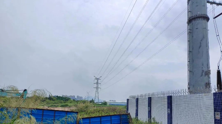
Survey area photos
Project Overview
The survey area is located in Zhaoqing City, Guangdong Province. This time, the Genius lidar + MMC-Tiger M9 fixed-wing UAV was used to inspect the 220 kV transmission line in the area, and point cloud data collection and 3D modeling were carried out. Provide power grid companies with reliable, comprehensive and quantified detailed information, further improve the power grid emergency surveying and mapping guarantee service mechanism, and improve the line operation and maintenance level.
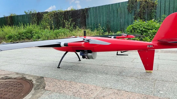
Genius lidar + winged tiger M9
Genius lidar features
Light weight: The system weighs 1.056kg, and the integrated camera weighs about 1.57kg; it is perfectly suitable for DJI M200/M210/M300/M600 series drones, and it is also suitable for a variety of drone carrying platforms, which is economical and practical.
Long range: the maximum range is 250m; the maximum altitude is 150m, which can ensure the safety of flight operations in the case of complex terrain and electromagnetic interference
High accuracy: the error in distance measurement is better than 2cm; the elevation accuracy is better than 10cm
Fast speed: 320,000 points/s or 640,000 points/s, point density > 200 points/m²
Convenient operation: support base station-free operation, one-key start
Winged Tiger M9 Vertical Take-off and Landing Fixed Wing Features
Vertical take-off and landing, 2-hour long battery life: vertical take-off and landing without runway, longer battery life, and a wide range of aerial survey operations.
Quick disassembly, 2 minutes to complete deployment: Equipped with MMC standard quick release system, which can quickly replace the load according to the task requirements. Genius' highly integrated design and modular M9 make the whole system have better performance and stability. It can acquire 3D spatial information and images of the terrain surface in real time and quickly, and is widely used in the field of agile and efficient 3D measurement.
Operation arrange
The flight altitude is 60m, the flight speed is 19m/s, and the flight is 20m above the power line side;
◉ Flight safety assessment in the survey area
According to the site conditions, select the take-off and landing site, deploy drones and Genius lidars;
◉ Flight planning route
Considering the requirements of operation safety regulations and flight safety, due to the visual error in visual judgment, under the strict compliance with the "safety first" operating principle, the drone operator takes off the drone to determine and inspect the height and point, and then The flight operation is carried out by means of automatic flight of the planned route.
◉ Take-off operation
After planning the route, take off and perform the flight collection task according to the established route;
◉ Flight Statistics
Plan the route according to the demonstration area, and a total of one flight operation was carried out on site;
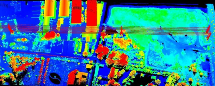
Data achievement display
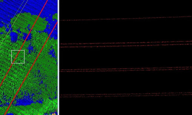
Power line continuous No disconnection
The area is covered completely and can accurately reflect the ground object information
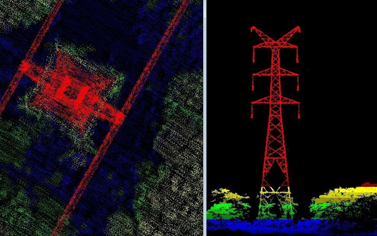
The side of the power tower (screenshot) The structure of the power tower is complete and clear
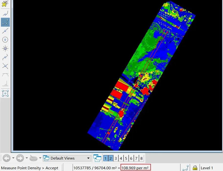
Average point density >109 per m²
Summarize
There are more fixed-wing UAVs than rotary-wing UAVs, which have the characteristics of fast flight speed, wide operation range and rich load. They are especially suitable for difficult patrol line sections such as crossing rivers and mountains. Extend the inspection distance and range to the greatest extent, and fully improve the inspection efficiency. The combined use of fixed-wing UAV technology and multi-rotor UAV technology can give full play to their respective advantages and characteristics, greatly improve the inspection efficiency of UAVs, and escort transmission line equipment.