
The most advanced surveying and mapping technology in the surveying and mapping industry is the use of "lidar" for surveying and mapping! The surveying and mapping lidar system, which integrates the three major technologies of laser ranging, global positioning and inertial navigation, provides an accurate and reliable technical means for obtaining geospatial information with high temporal and spatial resolution.
Lidar, which has the advantages of high density of collected original points, high accuracy of elevation, and strong penetration of vegetation, has become a "magic weapon" in the hearts of countless surveying and mapping people.
Under the dual promotion of technological evolution and rich scenes, the development of the surveying and mapping lidar track has been improving for a long time, and new products are also emerging in endlessly, even making surveying and mapping personnel into a "difficult choice syndrome." For surveyors, what kind of lidar is "easy to use" enough?
01
The history of using lidar for surveying and mapping scenes can be traced back to the late 1980s. The world-renowned university of science and technology-Universität Stuttgart combined GPS global positioning technology, inertial positioning technology and laser scanning technology to develop the world's first airborne laser scanner that adopts an "active measurement" method. Since then, in the field of surveying and mapping, a new surveying and mapping equipment and new surveying and mapping technology have officially appeared on the stage.
In the field of surveying and mapping, compared with traditional methods such as artificial, remote sensing satellites, and oblique photography, surveying and mapping lidar has the following outstanding advantages:
01
High precision
Because lidar adopts the "active measurement" that emits and receives high-frequency lasers, it naturally has significant advantages in perception. The laser point cloud data it produces has the characteristics of high density, large quantity, and complete details. It can well support high-precision topographic surveys, engineering surveys and other surveying and mapping requirements that require high accuracy.
02
efficient
Compared with traditional aerial surveys, airborne lidar, supported by 3D point cloud modeling, can accurately complete surveying and mapping operations without field image control point measurement, and can efficiently perform long-distance and large-area operations. At the same time, the airborne lidar system can meet the needs of high-precision image differential correction by optimizing the ground three-dimensional coordinates, and can produce digital orthophotos without using the expensive professional data processing platform of digital photogrammetry.
03
Comprehensive content
Lidar can obtain ground object information in real time. At the same time, it is extremely limited by weather conditions. The high-frequency laser of the sensing medium can also penetrate vegetation, achieving good operational effects in the scene of measuring vegetation-covered terrain.
Since its introduction for more than 30 years, lidar surveying and mapping has always been on the "throne" of the most advanced surveying and mapping technology in the industry. The performance of surveying and mapping lidar has also been continuously evolving under the continuous evolution of technology.
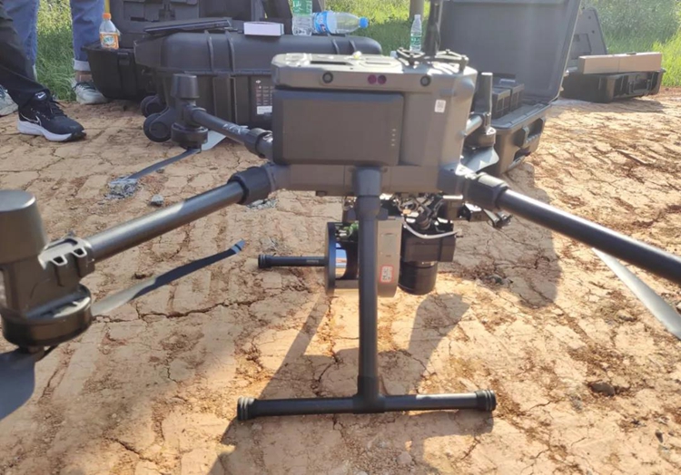
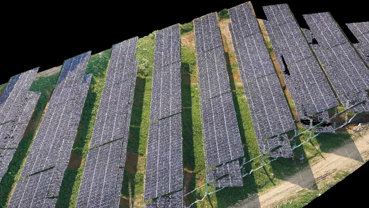
The Surestar product in Surestar's surveying and mapping product line-the micro airborne LiDAR system "Genius" integrates a 16/32-line lidar scanner, a high-precision POS system, an internal control unit and a 42Mp high-resolution SLR camera. The lidar scanner used in the Genius system, with a maximum range of 250m, a range of 2cm accuracy, and a measuring point frequency of 320 kHz/640 kHz, with high-precision inertial navigation system, it effectively ensures the high accuracy and completeness of Genius's three-dimensional space data collection during the flight.
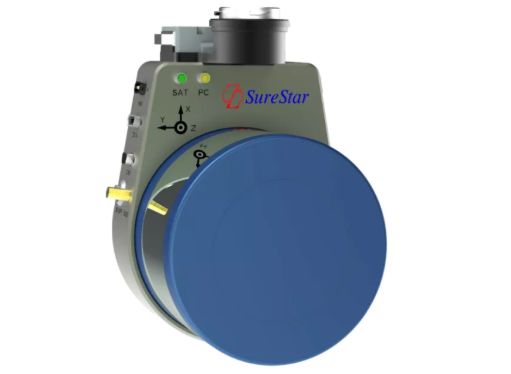
Genius Micro UAV LiDAR System
Another surveying and mapping LiDAR product "Magic pro" independently developed by Surestar is positioned at the beginning of the design as "a micro airborne LiDAR with powerful performance and 360° no short board". "Magic pro" has an elevation accuracy of 5cm, a maximum operating height of 200m, and an effective point density of 200/m² for a single flight belt. The measurement area for a single flight has reached 6km². Whether it is 1:500 topographic surveying, or surveying and mapping jobs that have specific needs in power and other industries, Magic pro is perfectly capable of doing it.
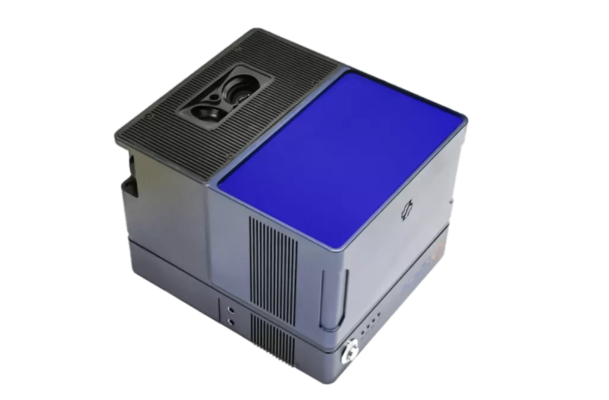
Magic pro (dual camera version) micro-UAV-borne lidar
While continuously making breakthroughs in performance, the application range of airborne lidar has also expanded. Lidar has been widely used in the fields of urban three-dimensional modeling, digital power grid, digital water conservancy, digital survey, ancient building protection, forestry application, etc., and it can be called the "magic oil" in surveying and mapping methods.
02
Merely the excellent surveying and mapping performance is not enough to make Lidar become the "magic weapon" in the hearts of countless surveying and mapping people. Only products that can fully solve the pain points of the surveying and mapping industry can become a "good LiDAR" favored by surveying and mapping people.
The manual measurement method requires surveying and mapping personnel to carry heavy equipment and measure the earth step by step with their feet.
After arriving at the survey area, the deployment of total station and other equipment is also very cumbersome. During the operation, it is necessary to constantly change stations to ensure the integrity of data collection, Increase the workload exponentially.
Traditional manual surveying and mapping methods require surveying and mapping personnel to carry a lot of bulky equipment
The inconvenience of the traditional aerial survey method is mainly due to the single data result. To meet the characteristic requirements of different scenarios, it is often necessary to carry other supporting equipment on the vehicle at the same time, or to extend the out-of-industry process, and then leave the survey area after collecting the data. Do processing. Regardless of the method, the compatibility of different devices and software will bring new inconveniences.
The various pain points in surveying and mapping tasks can be summarized in three words-inconvenience. LiDAR that is convenient enough to use is the "good LiDAR" in the hearts of surveying and mapping people.
In order to reduce the burden of surveying and mapping personnel carrying equipment, Surestar has worked hard to reduce the size of the surveying and mapping lidar, reduce the size of internal components under the premise of ensuring performance, and continue to optimize the system integration layout, in order to solve the problem of heavy equipment in the field surveying and mapping operations. Pain points such as difficulty in carrying, cumbersome deployment, and inconvenient transportation under special circumstances.
For the two products mentioned above, the total weight of the system after the "Genius" is equipped with a high-definition camera is only 1.7kg, and general light drones can easily carry them for operations. The weight of the "Fengdie" dual-camera version is also less than 1.25kg. With a small rotor drone, the total weight can even be less than 7kg, which has the advantage of loose air transportation worldwide.
Genius is less than half the length of a single rotor blade of a drone
In addition to being light and easy to carry, Surestar also provides a wealth of mature configuration solutions for "Genius" and other surveying and mapping lidars, which can achieve high compatibility with different flight platforms and different cameras. The field deployment is quick and the deployment time is better than 3 minutes under ideal conditions.
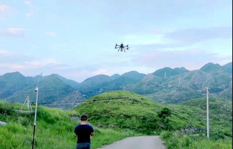
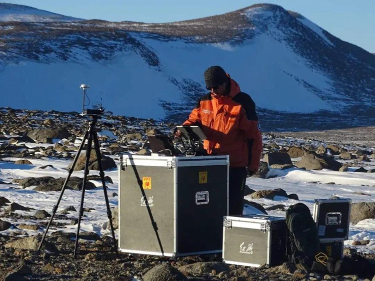
Genius-Flying on the ground, challenging 700 drop topographic mapping
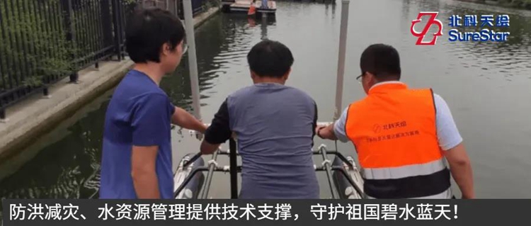
Genius-Water area surveying and mapping to help flood prevention and disaster reduction, water resources management
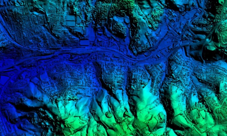
In terms of data results and software support, general light drones equipped with "Genius" can obtain high-precision three-dimensional point cloud and image data in the field of view synchronously through a single flight, so that the built-in trajectory generation software and point cloud preprocessing software in the system , With the support of software units such as the point cloud impact registration system and the 2D and 3D mapping system, 4D products such as DEM, DOM, DSM, DLG, etc. can be quickly produced.
Genius data achievement-color point cloud
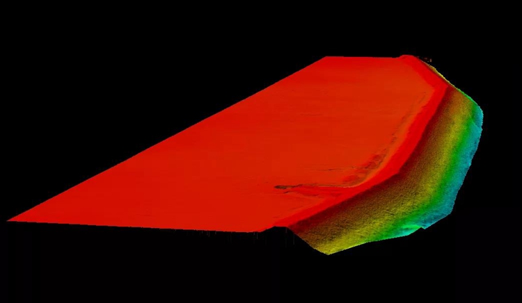
Genius data achievement-DEM
Magic pro's 100° ultra-wide field of view to the ground and 100% effective frequency of 265 Hz, combined with the dual-camera system of 48 million pixels, can not only achieve the simultaneous acquisition of laser data and image data, but also according to the specific needs of the job , Reasonably plan the route, and simultaneously establish a highly detailed and reductive tilt model, without the need to extend the non-industry process later.
In addition, as a veteran domestic lidar manufacturer that realizes the core components and technological autonomy of lidar, Surestar has complete product independent upgrade and maintenance capabilities. At the same time, Surestar has also established a professional and complete 7*24 hours after-sales service system, which can fully guarantee Customer needs in terms of after-sales service, upgrades, etc.
As a leading domestic lidar company, Surestar has been pursuing higher product performance in more than ten years of lidar product research and development. It has also always been from the perspective of users and usage scenarios, and insists on creating a solution that can effectively solve user pain points. LiDAR products bring continuity, batch, stability and precision to every project of every customer.(www.isurestar.net)