
The target survey area is located in a certain area in Fujian. The survey area mainly includes some mountainous forests, terraced fields, roads and other ground objects. The survey area belongs to a hilly area with complex topographical conditions.
Hilly area, geological survey tool
How does #Genius LiDAR# perform?
★ Difficulties in the survey area ★
The drop in a small range is large, and the drop in some steep areas changes rapidly, and the stability of the entire system is tested to a certain extent when flying at a higher altitude;
The vegetation in the mountains is densely covered, mostly eucalyptus forests, and there are many shrub layers growing on the ground;
There is a certain test for the "penetration" effect of lidar data;
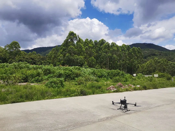
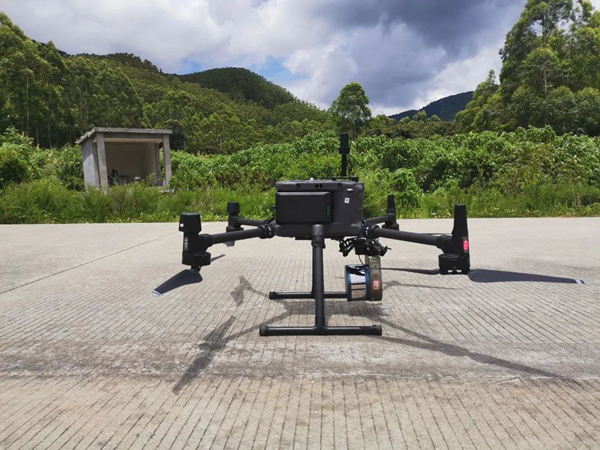
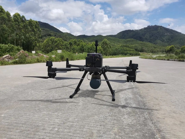
1.Genius LiDAR + DJI M300 UAV
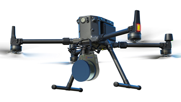
Light weight: The system weighs about 1.1kg, which is perfect for DJI M200/210/300/600 series drones;
Long range: the maximum range is 250m; the maximum flight height is 150m;
High accuracy: the scanner accuracy is better than 2cm; the system elevation accuracy is better than 10cm;
Fast speed: 320,000 pts/s, point density > 200pts/m²;
Super convenient: no base station operation, one-key start, 3 minutes to complete the deployment;
Long endurance: The battery endurance of the Genius LiDAR mounted on DJI M300 is better than 40min;
2. Field work process
(1) Flight safety assessment in the survey area
According to the terrain fluctuations on the site, select the take-off and landing site and deploy UAV LiDAR equipment;
(2) Flight planning route
Taking into account the quality requirements of the data results and flight safety, the flight with a variable altitude route is adopted:
Terraced fields and road areas at the foot of the mountain: use the level flight operation at a height of about 60-80m above the ground, and the flight speed is 6m/s;
For areas with a large drop in the mountainous area, the flight operation is carried out by changing the height to increase the flight height, maintaining a safe distance (about 50-70m higher than the forest trees) to the mountain trees, and the flight speed is 6m/s.
(3)Take-off operations
After planning the route, the LiDAR system is turned on with one key, and the working status of the equipment can be confirmed according to the equipment indicator light. After the status confirmation is completed, stand for 5 minutes for the initialization of the inertial navigation system. After the rest is completed, it will fly autonomously according to the planned route.
(4) Data solution
The operation adopts the PP-RTX free base station operation mode. In this operation mode, there is no need to set up static base stations. Through the Trimble global base station network service, static data can be obtained online in real time during the data processing stage, which can be used for GNSS differential calculation, which can effectively improve the efficiency of field operations.
3. Data achievement display
Raw data
POS: 42.1M; LiDAR data (isf): 4.5G
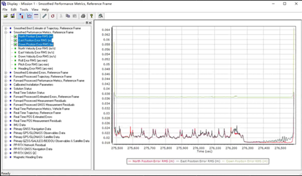
Trajectory accuracy
The trajectory (POS) plane position accuracy is about 2cm, and the elevation accuracy is about 3.5cm;
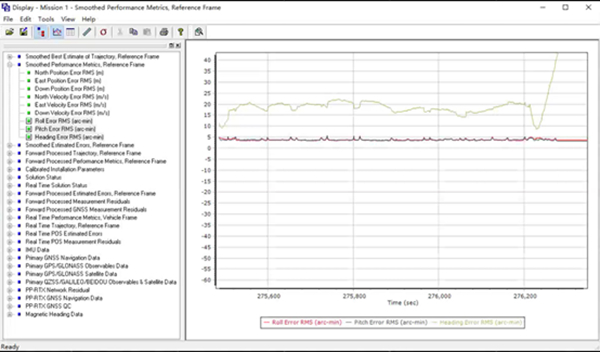
The trajectory (POS) roll and pitch attitude accuracy is better than 5 arc-min, and the heading accuracy is better than 20 arc-min;
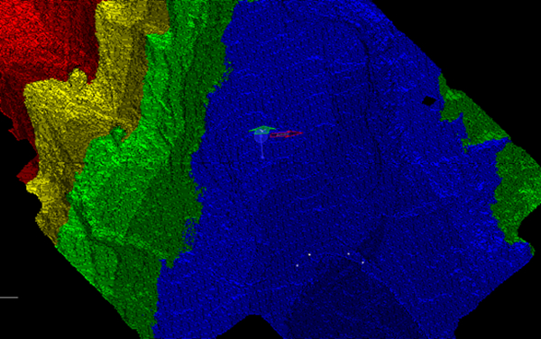
point cloud data
Complete data of the area (point density 290 points/m²)
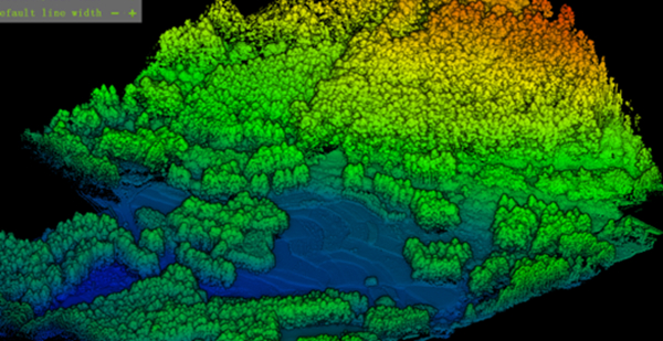
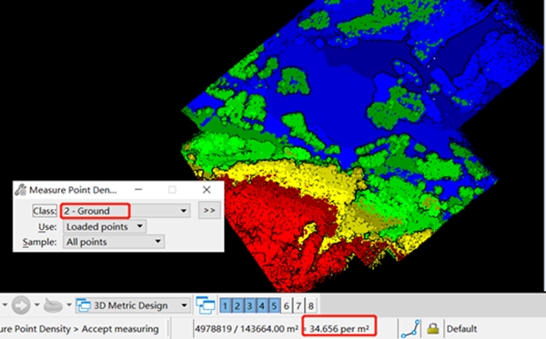
ground point effect
The surface of the dense vegetation coverage area is complete and continuous, and the terrain fluctuations are clear; the overall ground point density reaches 34 points/m²
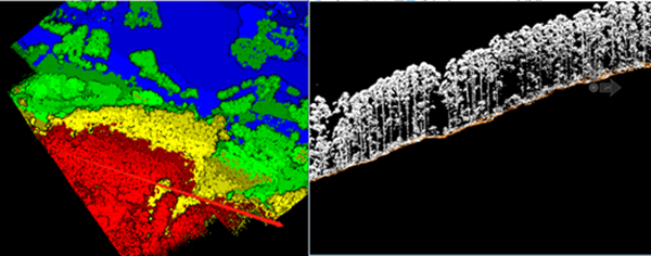
Laser point cloud data quality (accuracy)
The point cloud data obtained from different flight belts have good coincidence and high relative accuracy. The system has high stability and reliability
DEM and surface elevation grid results
High-resolution DEM model data
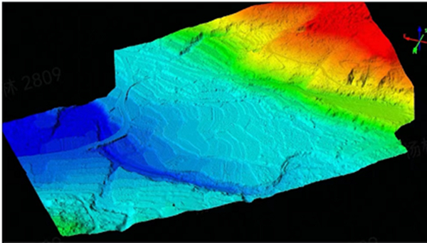
1m*1m elevation grid (CASS supported format)
4. Summarize
Genius LiDAR system is suitable for 1:500 scale mountain terrain mapping requirements. The point density and LiDAR point cloud accuracy both meet the "1:500 Topographic Mapping Airborne Lidar Data Acquisition Specification";
The system cooperates with professional processing software to output high-precision DEM model and DEM grid elevation point results. Meet the needs of generating topographic map results with applicable LiDAR data processing software or traditional mapping software;
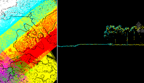
In dense forest areas, the Genius LiDAR system has a good "penetration" effect, and can quickly, effectively and accurately obtain surface information under vegetation. Compared with traditional surveying and mapping or photogrammetry, it has unparalleled efficiency and precision advantages;
LiDAR is becoming a new weapon for terrain mapping, and for many fields such as digital cities, intelligent transportation, and smart ecology, Lidar, as one of the emerging technologies, is also playing a cornerstone role in the digital architecture.
Traditional surveying and mapping technologies are no longer suitable for more and more complex topographic survey projects. As a low-cost, lightweight, and high-efficiency topographic survey tool, Genius LiDAR has solved the complex topographic surveying and mapping problems brilliantly, and has contributed to the prevention and control of natural disasters in mountainous areas. Provides precise digital support. Only cost-effective products can truly stand the test of the market. SureStar is accelerating the construction of the digital economy, and is also accelerating the pace of industrialization and scale of LiDAR.