Test report of Genius Lidar system of Quancheng Ultra-high Voltage Station
(1000KV)
Test Time
27th July 2020-28th July 2020
Unit of Test Zone
Intelligent UAV Business Unit of State Grid
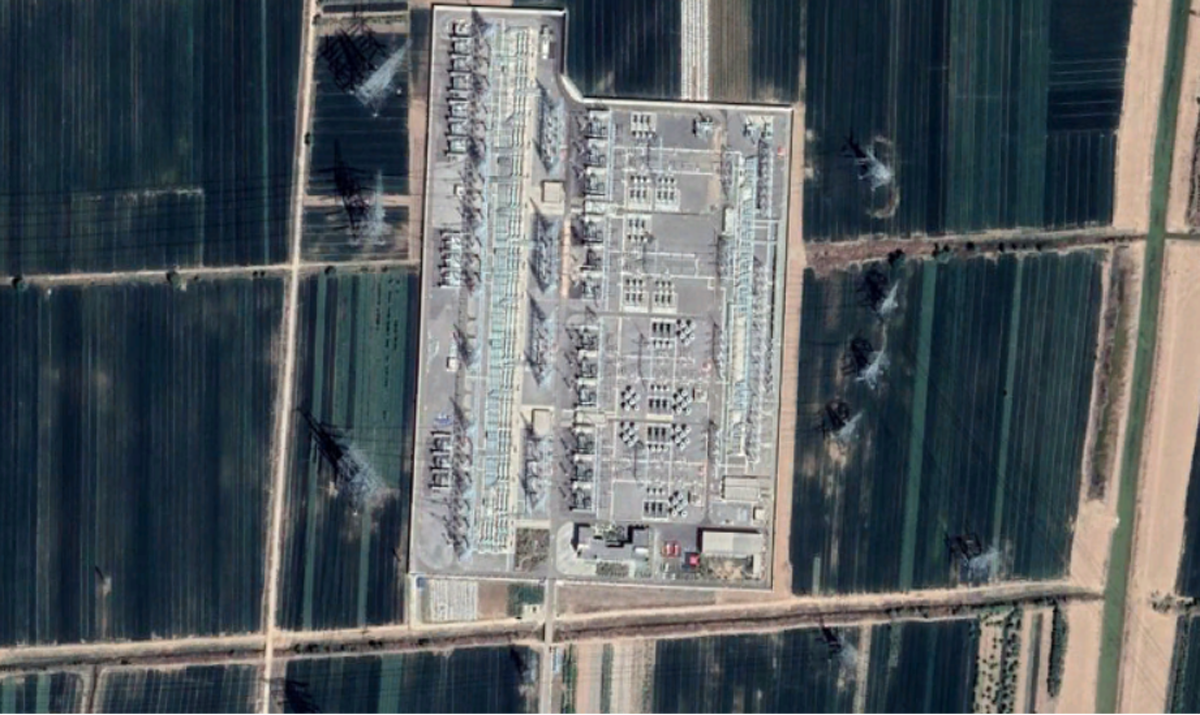
Profile in measurement area
Target measurement area: Located at Quancheng Ultra-high Voltage Station (1000KV), 5 km north of Renfeng Town, Jinan
Difficulties in the survey area:
Uhv substation, strong electromagnetic interference
Complex internal structure in substation, the parts keep out clearly
There are electrical towers higher than substation in the substation area
New measurement area, strange environment

Testing Device
1. Lidar
Genius lidar system has the following characteristics
Light weight: the system weighs about 1.1 kg, can be directly mounted on DJI M200/210/300/600 series unmanned aerial vehicle (UAV)
Long measurement range: the maximum range is 250 m; The maximum flight height is 150m, which can guarantee the safety of Flight operation under complicated terrain and electromagnetic interference
High precision: ranging accuracy is better than 2 cm; The system elevation accuracy is better than 10cm
Speed: 320000 PTS/s, point density > 200 PTS/square
Convenient: free base station operation, one-key start

1. Flight platform
DJI M300 UAV has the following characteristics
Long-range: operation time is more than 40 min when mounting with Genius;
Six eye vision: support high-speed obstacle avoidance, ensure the safety of flight operations to the greatest extent;
Convenient operation, quick field deployment, convenient mounting of Genius, the deployment on time less than 3 min.

Field Operation
1. Operation process
(1) Flight safety assessment in the survey area
According to the site conditions, select the landing site, deploy unmanned Lidar System;
(2) Flight route planning
Taking into consideration the requirements of on-site operational safety regulations and flight safety, due to the visual error of visual judgment, the drone operator takes off the drone to determine and inspect the height of the drone under strict compliance with the "safety first" operating guidelines.
For the internal area of the substation: use the automatic flight method of the planned route for flight operations, altitude: 80m, speed: 4m/s, and route spacing 40m;
For high towers and power lines at the periphery of substations: According to information such as the direction of power lines and tower height, the drone is operated in an autonomous mode for flight operations.
(3) Take off operations
After planning the route, take off and perform flight collection tasks according to the established route. The electrical tower and power lines adopt an autonomous flight mode. Due to compliance with flight operation regulations and flight safety, there is no flight coverage in areas close to substations and power lines crossing.
(4) Data field calculation
Due to the PP-RTX data solution service, there is no need to set up a ground static base station for flight operations. The data can be solved immediately after the flight, and the on-site quick and efficient solution can quickly check the data quality.


Point Cloud


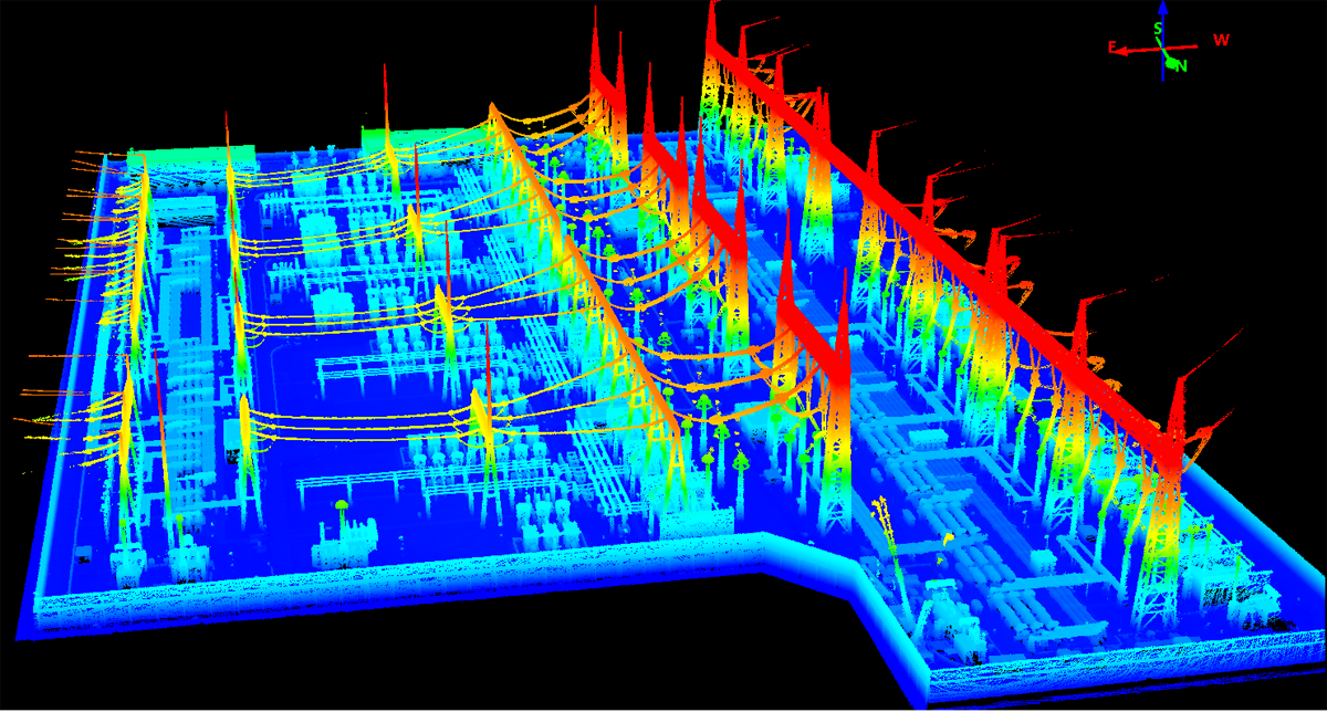


In the periphery of the substation, except for the locations not covered by the flight that affects the flight and the safe flight of power facilities, the towers are complete and the lines are clear.


110m and 130m towers can be scanned clearly and accurately


High precision
Due to the inconvenient access inside the substation, Qianxun collected elevation verification points and feature check points at the entrance of the substation. After verification and evaluation:
Lidar point cloud:
The plane accuracy is better than 15cm;
The elevation is better than 10cm.


Conclusion
The Genius Lidar UHV Substation Operation:
Thanks to the advantages of the Genius lidar's long measurement range, it can still guarantee better scanning effects and efficiency under the premise of fully ensuring safety and redundancy;
Equipped with the M300 flight platform, the field operation deployment is efficient and fast, the battery life is long, the power fully meets the complete flight in the substation area, and the battery reserve is sufficient to support the second flight;
Using the base station-free operation mode, there is no need to carry and erect static reference stations, which can effectively reduce the cost of operating personnel and equipment;
The equipment is simple to operate, directly mount the flight platform, and start the operation with one button, without complicated settings for the radar;
On-site data calculation, PP-RTX does not need to manually upload or download data, and data can be solved immediately without waiting after the flight.