
On April 19, Surestar released its first self-developed handheld 3D laser scanner-"StarScan", which aims to solve the "laser scanning last mile problem".
With its excellent measurement performance, small and light body shape and excellent user experience, in just two months, it has been unanimously praised by customers from different industries. After using "StarScan", some surveying and mapping personnel commented: "This product can be called a Decathlon, and it can meet many of our different measurement needs."
Today, let Xiaohui take you to get a glimpse of the Decathlon of "StarScan" and in which scenes it is showing its prowess!
A new star of surveying and mapping adapted to a closed environment
Regardless of the number of subdivided tracks or the overall market size, laser scanning equipment is indeed becoming more and more popular.
A report released by China Research Network in June 2020 shows: According to end users (industry), the main tracks of the 3D laser scanning market include construction and construction, energy and power, tunneling and mining, automotive, medical, aerospace, and defense , Man-made and heritage protection, etc.
In terms of market size, according to the prediction of China Research Network: By 2022, the 3D laser scanner market will reach 3.74 billion U.S. dollars, with a compound growth rate of over 8% from 2017 to 2022. One of the main factors driving market growth is 3D laser. The application scenarios of scanning equipment continue to be enriched, and various industries have begun to deploy a large number of 3D laser scanners.
As the 3D laser scanner market has entered a period of accelerated development, the diversification of application scenarios also makes the market place higher demands on the 3D laser scanner itself. For example, in a closed, narrow, narrow and long venue environment, airborne equipment is useless, site-based and vehicle-mounted are expensive, low in efficiency, and limited in use. Faced with such an environment, the "StarScan", which weighs less than 1.3kg and is flexible and compact, has unique advantages.
For indoor surveys in buildings, or other scenes that are difficult to access with site-based and vehicle-mounted laser scanners, "StarScan" can easily and smoothly complete surveying and mapping operations. And only one person can operate it.
For example, in the underground garage survey scene, although the site-type laser scanner can enter the field for operation, the equipment is huge and requires frequent station changes. Both the labor cost and the time cost are very high. Although the vehicle-mounted laser scanner is more efficient, the vehicle-mounted laser scanner may have a certain measurement dead angle under the influence of two factors: the relative position of the carrier and the scanning device and the size of the carrier.
In the face of such situations, the "StarScan", which can be held by a single person and operated independently, can undoubtedly greatly save the cost of surveying and mapping operations, and accurately measure every detail of the target area without blind spots. And in the absence of GPS signal, "StarScan" can also accurately match the point cloud with its new high-precision SLAM algorithm to complete the job.
In narrow and long spaces such as tunnels, corridors, and even pipelines, "StarScan" can still enter the site smoothly, giving full play to its super-strong sensing ability as a lidar product in surveying and mapping operations.
The vast world is also the stage for StarScan
The outdoor open environment is also a stage for "StarScan" to show its talents. In the engineering field in a broad sense, it is often necessary to measure some small, medium, and even miniature single targets in the context of surveying and mapping. The use of site-mounted or vehicle-mounted scanning equipment to complete the above-mentioned types of measurement operations will inevitably face the same problems as those of closed-environment measurement operations: high cost, long time, and possible data gaps.
If airborne equipment is used for operations, not only is it a “killing a sledgehammer” from the perspective of measurement range and cost, the advantages of the “God’s perspective” airborne equipment will be due to the detailed dimensions and three-dimensional structure of the measurement target. Become a disadvantage. Taking the scanning surveying and mapping before the restoration of ancient buildings as an example, it is difficult for the airborne lidar to obtain complete information about the positions under the eaves and inside the doorway.
In the face of such surveying and mapping operations, the performance of "StarScan" can be described as a duck in water. Surveying and mapping personnel can complete a truly comprehensive measurement of every angle and every detail of the target without being restricted by site conditions.
In small-scale measurement scenarios such as parks and municipal facilities, "StarScan" also realizes the "all-in-one" surveying and mapping operation, which can give full play to its high efficiency, convenience, and accuracy, and avoid frequent station-based equipment replacement and the possibility of vehicle-mounted equipment. There are problems such as blind spots in blind spots and inability of airborne equipment to cope with occlusion.
"StarScan" also has a 9-degree-of-freedom inertial navigation system, which can guarantee the quality of measurement data even if the ground is up and down in the working environment. In forestry investigation scenarios, "StarScan" can restore the bottom structure of the forest with high accuracy and accurately measure the diameter of trees at breast height. In addition, in densely-vegetated areas, "StarScan" can also efficiently obtain ground point data.
In addition, "StarScan" has a convenient design of a one-button start mechanism and a standardized replaceable battery module, and adopts tilt compensation technology, supports automatic correction of horizontal ±10°, allowing surveying and mapping personnel to complete it more easily and efficiently Single target or small-scale surveying and mapping operations.
The best answer to "laser scanning the last mile problem"
In addition to the typical measurements in various scenarios, the "StarScan" praised by customers as the "Decathlon" has other eye-catching performances.
StarScan has a tilt measurement mode. In the face of power towers that are tens of meters high, surveying and mapping personnel do not need relatively expensive airborne lidars that need to set up routes and other parameters. They can use "StarScan" to complete operations on the ground.
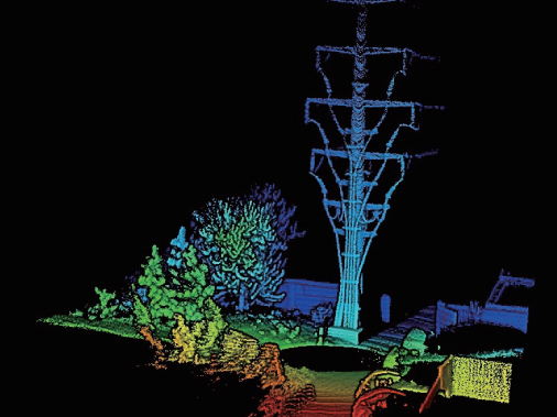
StarScan-Power Pole Tower Point Cloud
Affected by the continuous increase in the number of engineering and infrastructure projects, large-scale construction projects such as bridges, multi-storey buildings, highways, and industrial plants have higher requirements than ever in terms of the number of projects and engineering efficiency. This has again given " "StarScan" has the opportunity to express its own advantages.
Regardless of the scale, infrastructure projects are inseparable from volume measurement operations. Take pile measurement as an example, "StarScan" can obtain high-precision registration point cloud data without target orientation or GPS-assisted positioning. It is even possible to quickly establish a digital surface model for detecting the pile body without absolute coordinates, and to calculate the pile body volume through the comparison between the model and the measurement datum surface.
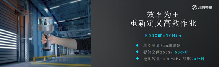
Such "Decathlon" supports the excellent performance of "StarScan" in terms of performance parameters: 200m core 3D ranging, centimeter-level data accuracy, 320,000 dots per second scanning speed, 360° no dead angle omni-directional field of view , Excellent parameters allow "StarScan" to complete the data collection and processing of 5000m² work area in less than 10 minutes.
In product design, in order to enable "StarScan" to effectively solve the "last mile problem" of lidar and apply it to more scenarios, Surestar has also worked hard in many aspects other than measurement performance. The industrial protection grade of IP54 allows it to operate normally in special environments such as light rain, heavy fog, and seaside.
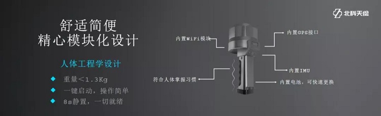
In addition, the operation of "StarScan" is very convenient, and beginners can use it after about five minutes of learning. In terms of static data convergence, "StarScan" only needs to stand for 8 seconds, then you can continue to use this device for the next job. With ergonomic design, 1.3kg weight and 3400 mAh replaceable battery module, "StarScan" is undoubtedly better adapted to continuous operation.
Efficient and accurate measurement, versatile site adaptability, and user-friendly experience make "StarScan" the best answer to "laser scanning the last mile problem", and its application range is far beyond what is described in the article. Today, as new demands for surveying and mapping emerge in endlessly, more digital twin real-life 3D scenes are waiting for you to explore!(https://www.isurestar.net/)