
A rapidly changing digital China is coming to us!
As an important part of Digital China, digital transportation is constantly stimulating digital potential and drawing a new blueprint for a beautiful digital China. Today's world is entering a period of economic development dominated by the information industry.
The new generation of information technology represented by artificial intelligence, quantum information, mobile communications, Internet of Things, big data, blockchain, and digital twins accelerates breakthrough applications. Digitization and intelligence have become important engines for increasing the speed of national economic development. Digital transportation Has become the general trend.
With policy support, digital transportation has become a future trend
In July 2019, the "Digital Transportation Development Plan Outline" proposed to build a digital collection system. Build a high-precision transportation geographic information platform covering the whole country, improve element information such as transportation engineering, and realize the three-dimensional digital presentation of physical facilities.
In 2020, the Ministry of Transport's "Guiding Opinions on Promoting the Construction of New Infrastructure in the Transportation Field" pointed out that by 2035, significant results will be achieved in the construction of new infrastructure in the transportation field, and smart trains, autonomous vehicles, and smart ships will be gradually applied.
On March 14 this year, the Fourth Session of the 13th National People’s Congress passed the "Fourteenth Five-Year Plan for National Economic and Social Development of the People’s Republic of China and the Outline of Long-Term Goals for 2035", which also pointed out the development of smart transportation and autonomous driving. Travel services that are coordinated with vehicles and roads.
Black technologies in the transportation field are emerging in an endless stream, and new technologies such as 5G, VR, and autonomous driving continue to emerge, and are continuing to accelerate the application of virtual reality and digital twin technologies in more scenarios in the digital transportation field.
Digital twin application landing exploration proceeded in an orderly manner
The concept of digital twins was first proposed by Professor Dr. Michael Grieves of the University of Michigan. In an article he published in 2002, he believed that through the data of physical devices, a virtual entity that can represent the physical device can be constructed in the virtual (information) space. And subsystems, and this connection is not one-way and static, but is connected throughout the life cycle of the product.
Digital twin is to make full use of physical model, sensor update, operation history and other data, integrate multi-discipline, multi-physical quantity, multi-scale, multi-probability simulation process, complete the mapping in the virtual space, thereby reflecting the full life cycle of the corresponding physical equipment Process.
In practical applications in various fields, digital twins are mainly embodied in the aspects of condition monitoring, real-time control, scientific research and judgment, and experimental simulation. Through three-dimensional models and visualization methods, various professional data are collected on the same management platform for intuitive presentation. , To broaden corporate boundaries, break down departmental information barriers, and promote the digital mainline between different departments.
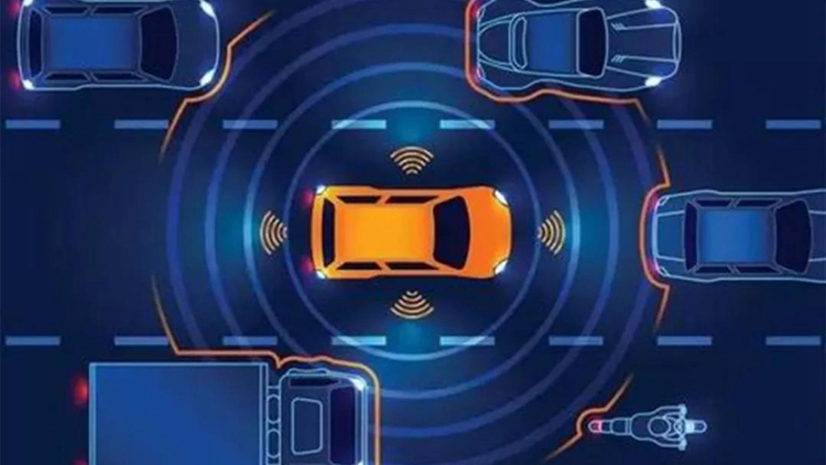
According to statistics from the Ministry of Public Security, the number of cars in my country will reach 281 million in 2020. If calculated on the basis of a population of 1.4 billion, it is equivalent to 1 out of 5 people owning a car. In the face of high car ownership rates and complex and diverse driving scene changes, how to improve the adaptive capabilities of vehicles to ensure the stability of daily driving has always been a pain point for smart transportation.
And through digital twin technology, intelligent transportation will be empowered from many aspects to meet the needs of future travel.
Lidar provides new solutions for traffic digital twins
In the field of digital transportation, digital twins also have a wide range of applications in autonomous driving testing, traffic construction planning, scientific decision management and scientific research and judgment. The digital twin world conducts safe and efficient smart car factory selection tests, saving enterprise costs and time, and improving the efficiency and quality of car companies.
The first solution to the construction of digital twins is to visualize time and space information. With the help of drone aerial photography and lidar scanning, road traffic data is quickly collected, and based on high-precision three-dimensional point cloud data, three-dimensional real-world modeling is completed and refined three-dimensional topographic maps are produced. Digital transportation provides visual data support for the whole process.
Lidar technology is synonymous with three-dimensional point clouds. As a core sensor in the fields of geographic surveying and mapping, real three-dimensional, and autonomous driving, it can collect high-precision geographic data, road data, and driving data. According to the platform, there are mainly the following four types: 1. Airborne lidar. Mainly use airplanes and unmanned aerial vehicles (UAVs or "unmanned aerial vehicles") to collect data; 2. Mobile Lidar, installed on moving vehicles; 3. Ground Lidar. Usually use a tripod to collect data from a static platform; 4. Hand-held lidar.
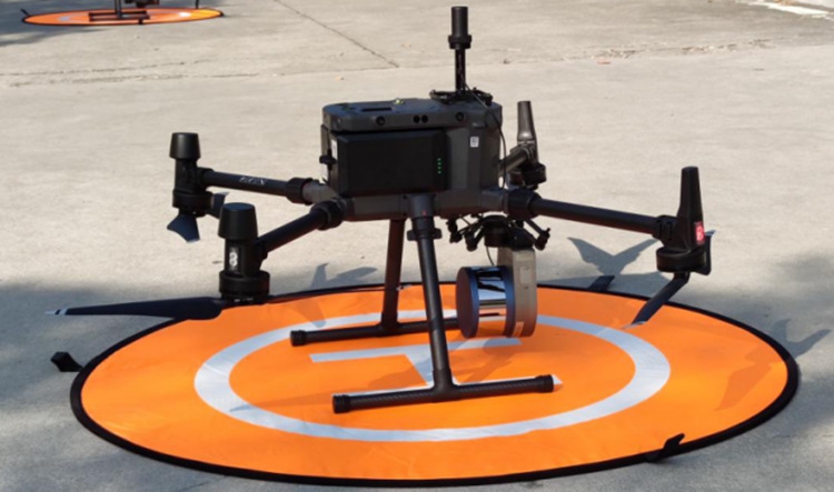
Surestar Genius Mini UAV LiDAR System
UAV-borne lidar mainly uses lidar scanning to obtain three-dimensional point cloud model data, and combines image files to perform dynamic analysis and simulation of urban roads in three-dimensional and four-dimensional (including time) levels, so as to realize the scanning range of urban roads. Full coverage, full coverage of attribute status, full coverage of location structure.
Surestar Hummingbird Genius Micro UAV LiDAR System is a cost-effective surveying and mapping-level lidar system independently developed by Surestar.
It integrates R-Fans multi-line laser scanner, inertial navigation measurement system (GNSS/IMU), computer control unit, etc., and has a single-soldier lidar measurement system with high integration, light weight, and high data accuracy. The total weight is only 1.168kg, of which the weight of the scanner is only 738g, which is flexible and convenient for low-altitude operation. The farthest distance measurement is 250m, the measurement speed is 640,000 points per second, the system distance measurement accuracy is 2cm, and the absolute accuracy is better than 10cm, which can meet the topographic surveying work of the largest scale 1:500.

Surestar R-Angle Mobile LiDAR
Mobile lidar is one of the effective tools for city modeling. Its principle is basically to add a 3D laser scanner to the POS system on the vehicle, so that DTM models can be built in a longer and farther range.
The R-Angle series of vehicle-mounted lidars independently developed by Surestar are suitable for vehicle-mounted measurement systems. They are light in appearance and weigh only about 3.5kg. They have high scanning frequency and long scanning distance. They have full coverage of 300-1500m range, combined with inertial navigation and global positioning system. , The application of laser and photogrammetry technology can quickly obtain the three-dimensional data of the road and its two sides during the high-speed driving of various mobile platforms. It is economical for engineering applications such as road, bridge and ancillary facilities survey, city three-dimensional modeling, etc. The efficient data acquisition method represents a new breakthrough in the efficiency of ground mobile laser data acquisition.
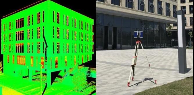
U-Arm Terrestrial Laser Scanner
Ground lidar usually uses a tripod to collect data from a static platform. The U-Arm ground 3D laser scanner independently developed and produced by Beike Tianhui is mainly a large-range pulse laser scanner product for geodetic surveying and engineering surveying and mapping. It has strong adaptability to environmental conditions such as illumination, target reflection and roughness. , Long measuring distance, wide scanning field of view, lightweight equipment, super high data collection efficiency, very suitable for on-site large-scale surveying and monitoring work. U-Arm ground 3D laser scanner, as the right-hand man of surveying technicians to complete diversified survey tasks, has been successfully applied to cultural relics protection, urban building surveying, topographic surveying and mapping, mining area surveying and mapping, road construction, tunnel/bridge reconstruction and other fields.
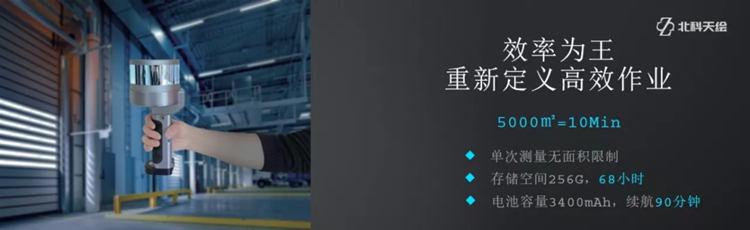
Hand-held lidar is mainly used for related surveying and mapping work in handheld mode. It is small in size and easy to carry. It can help people better explore real-life 3D and digital twin scenes. The first handheld lidar device independently developed by Surestar-"StarScan", weighs only 1.3kg, one-key start, easy to learn, easy to use, high integration, and can easily enter almost all work sites. "StarScan" has a high-precision SLAM algorithm, high accuracy, convenient use, and ergonomic design. It can realize single-person operation, that is, walk and scan, and complete, which greatly reduces cost input and greatly improves work efficiency.
Summarize
At present, the above-mentioned products have been widely used in smart cities, smart parks, smart transportation and other related fields, helping the country realize a new model of efficient and comprehensive governance.
With the development of digital transportation, digital twins will show their talents under a variety of new technologies, new models, and new formats.
The wind is rising and sailing, striving to cross again. This year is the first year of the 14th Five-Year Plan. Digital transportation is booming. The digital twin technology dynamically perceives the real world in real time and breaks through the barriers between the real world and the virtual world. The future market space is full of imagination. As one of the earliest companies engaged in the research and development of lidar products in China, Surestar is fully committed to bringing better products to the smart transportation industry of the motherland!(www.isurestar.net)