
Under the continuous and intensive media exposure, lidar can be described as fire from the beginning of the year to the end of the year.
In this year, the outside world's understanding of lidar is no longer limited to autonomous driving and geographic mapping. As the margins of industrial integration are repeatedly broken and reconstructed, the curtain of unlimited possibilities of lidar has been slowly opened.
The application scenarios of lidar have even expanded to some seemingly "unreachable" fields, such as ophthalmology, smart phones, household sweeping robots...
Now let Xiaohui take you to take a look at the various application scenarios of Surestar's lidar product family!
01
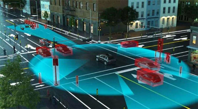
Benefiting from the evolution of the autonomous driving industry, the navigation obstacle avoidance type has become the most widely known type of LiDAR product in recent years, and is known as the "eyes of autonomous driving" lidar, after overturning the three mountains of "car regulations", "cost", and "lightness and miniaturization" one after another, It has quickly won the favor of most established car companies and new car manufacturers, and has become the core sensor of the high-end autonomous driving perception system generally recognized in the industry. With the release of autopilot models equipped with lidar, the general trend of large-scale lidar "on the car" is a foregone conclusion.
The C-Fans series and R-Fans series lidars in Surestar’s navigation product line have won the favor of many autonomous driving companies with their excellent performance derived from Surestar’s more than ten years of laser radar technology product research and development experience. The "appearance rate" on the autopilot test site and the actual road section is getting higher and higher.
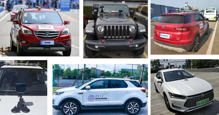
In addition to self-driving passenger cars, the navigation and obstacle avoidance lidar developed by Surestar is also widely used in many fields.
In the outdoor scenes of special vehicles, Surestar LiDAR products can well deal with the difficulties of driving bumps in the field, no obvious feature points in information collection, no image control points, and poor lighting conditions at night. Ensure the accuracy and stability of perception in a complex and changeable environment.
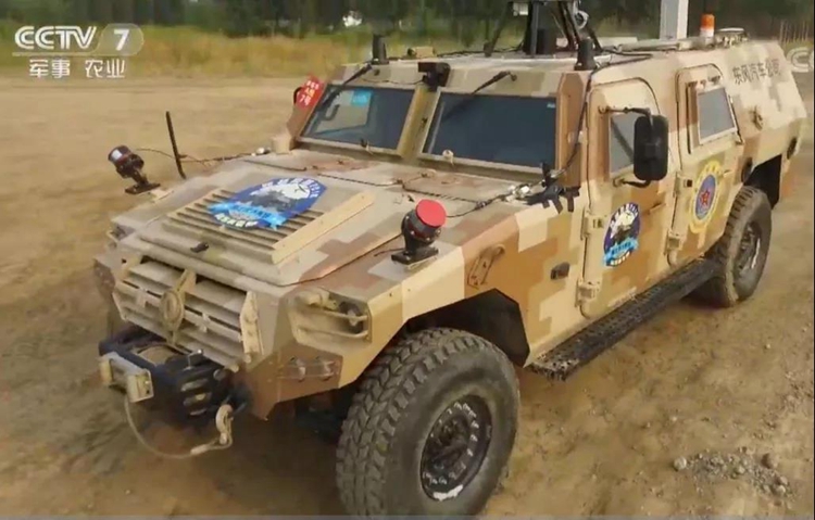
CCTV report: Surestar Lidar appeared in the scene of special vehicles in the wild environment
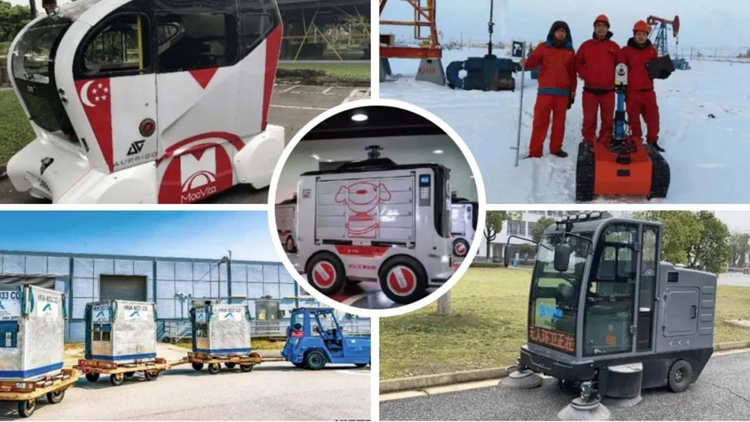
In scenes where the operating environment is relatively fixed, Surestar LiDAR products are even more proactive. We can find C-Fans/R-Fans series lidars on special vehicles such as unmanned logistics vehicles, unmanned sanitation vehicles, port AGVs, and oilfield inspection vehicles.
Based on the precise sensing capabilities of lidar, in addition to being applied to various vehicles and vehicles themselves, lidar can also provide powerful help for the construction of high-end autonomous driving and even unmanned driving environments.
Surestar R-Fans lidar uses its own advantages such as long core distance measurement and fast scanning speed to quickly and economically construct road high-precision point clouds, providing important data basic support for high-precision maps.
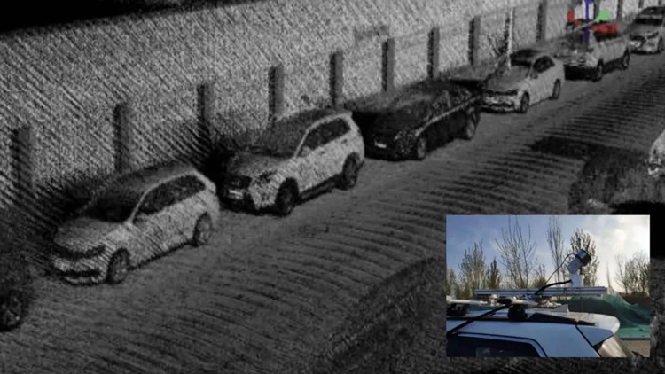
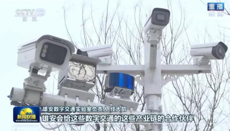
In terms of vehicle-road collaboration, in the vehicle-road collaboration project of the Digital Transportation Laboratory of Xiongan New Area, Surestar C-Fans-128 car-gauge solid-state lidar is used, based on the ROS platform, through the lidar point cloud extraction, the ground and The five steps of non-ground point cloud segmentation, target detection, target recognition and target tracking of target point cloud clusters detect the size of the target, distance and classify the target, and have achieved remarkable results, and have been reported by CCTV news simulcast program.
At the same time, the navigation obstacle avoidance lidar independently developed by Surestar is also used in fields far away from automobiles, such as agriculture, fire rescue, and rail transit.
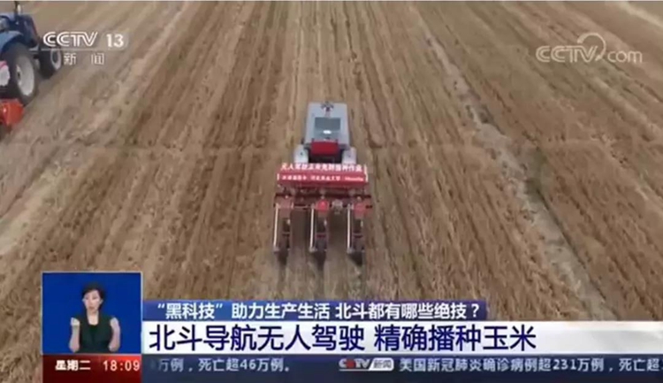
CCTV report: Beidou navigation + Surestar LiDAR helps smart agriculture precision seeding
The precise sensing ability of lidar and the strong anti-interference properties of high-frequency lasers can make it easy to "penetrate" the billowing smoke at the fire site, providing rescuers with clear vision and higher security.
R-Fans radar smoke test: comparison of real shot images of the survey area
R-Fans radar smoke test: point cloud image comparison of the survey area
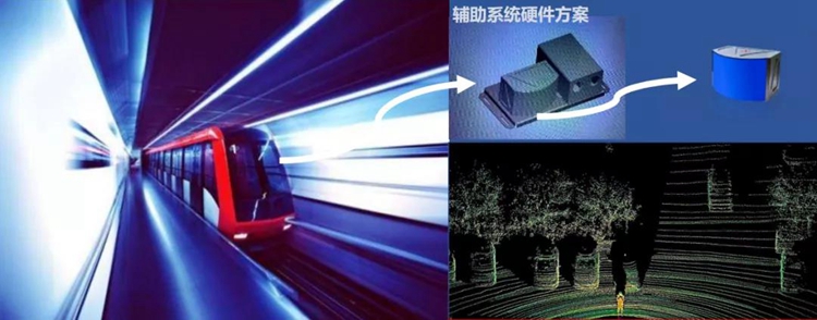
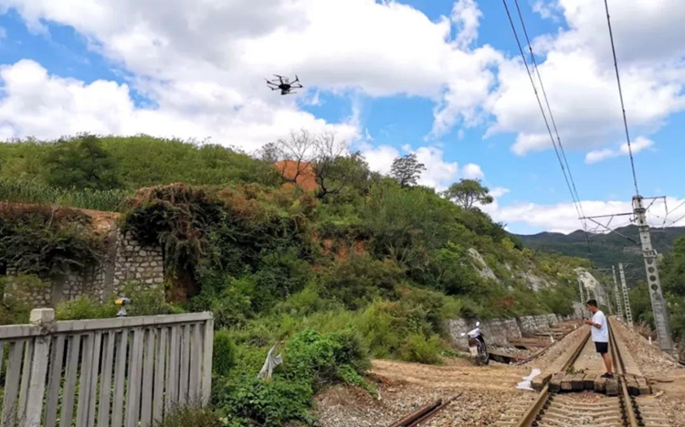
In urban rail transit systems such as subways and light rails, the use of lidar to build auxiliary system hardware solutions can greatly enhance the timely degree of trains' perception of sudden situations or environmental changes in the road network during operation.
02
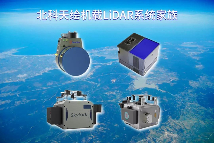
As the longest category in the lidar family, surveying and mapping lidar has been commercialized for nearly 30 years. As one of the earliest companies engaged in lidar research and development in China, Surestar has many types of airborne lidar systems such as Skylark, Yunying, Genius, and Wind Butterfly in its surveying and mapping product line. And it plays an important role in geographic surveying and mapping and many other subdivisions.
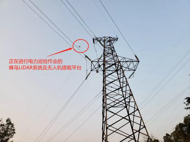
Take the micro-UAV LiDAR system Genius as an example. In the power facility inspection scenario of the power industry, Genius with a point density of more than 200 points/㎡, a system ranging accuracy of 2cm, and an absolute accuracy of better than 10cm, can rely on its real-time The ability to obtain three-dimensional spatial information and image characteristics of the terrain surface greatly improves the efficiency of power inspection in complex environments such as the field, and ensures extremely high accuracy.
Compatible with a variety of UAV platforms, Genius is simple and quick to deploy, with a maximum range of 250m, a scanning field of view of 360°, and a high scanning frequency of 320kHz/640kHz. In emergency rescue scenarios, it can help rescuers quickly learn data results such as three-dimensional point clouds in key areas of the scene that are difficult to reach from the ground, and provide a basis for decision-making for disaster relief operations.
Genius participated in the rescue of a mudslide disaster in a railway section in North China
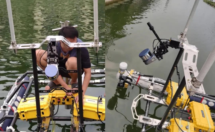
In addition, the airborne lidar system soaring in the sky can also empower the field of smart water conservancy. Realize accurate and efficient riverbank, water body and even underwater surveying and mapping through laser radar, which is the basis for the construction and operation of water conservancy, transportation and other wading projects, and provides technical support for flood control and disaster reduction, and water resources management.
03
Surestar released this year's first handheld 3D lidar scanner-"StarScan", which is an artifact of surveying, mapping and measurement designed to solve the "last mile problem of laser scanning". Although it is a newcomer in Surestar's product family, StarScan is no less inferior to many of its predecessors in terms of coverage.

Excellent measurement performance, small and light body shape and excellent user experience enable StarScan to penetrate into locations where a large number of other products cannot smoothly enter the site to carry out operations.
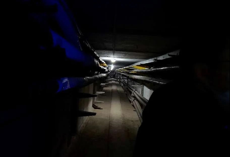
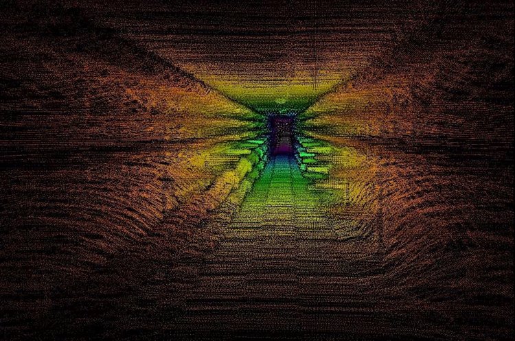
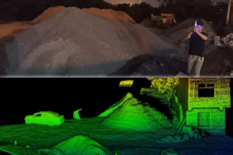
For example, in the underground garage measurement scene, the StarScan, which can be operated independently by a single person, can undoubtedly greatly save the cost of surveying and mapping operations compared with site-type and vehicle-mounted scanners, and accurately measure every detail of the target area without blind spots. And in the absence of GPS signal, "StarScan" can also accurately match the point cloud with its new high-precision SLAM algorithm to complete the job.
The single-person operation feature makes StarScan very popular in the infrastructure field. In the face of rigid operations in infrastructure projects such as earthwork, piles, and slope measurement, "StarScan" can obtain high-precision registration point cloud data without the need for target orientation or GPS-assisted positioning. It is even possible to quickly establish a digital surface model of the detection target without absolute coordinates, and calculate the data required by the engineering personnel through the comparison between the model and the measurement datum.
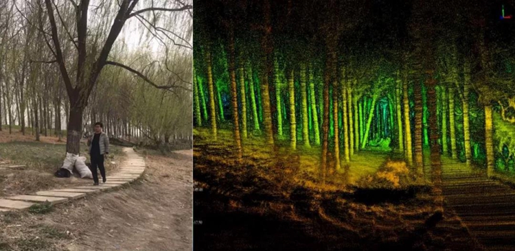
Even if the working environment is undulating, StarScan can guarantee the data quality of the measurement operation. In the forestry investigation scene, "StarScan" can restore the bottom structure of the forest with high accuracy and accurately measure the diameter of trees at breast height. Moreover, in densely vegetation areas, "StarScan" can also efficiently obtain ground point data.
On the basis of portability and ease of operation, StarScan integrates rich support functions such as tilt compensation technology and 9-DOF inertial navigation system. The overall product performance without shortcomings makes StarScan theoretically able to cover almost all surveying and mapping needs.
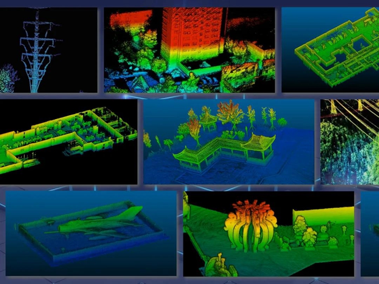
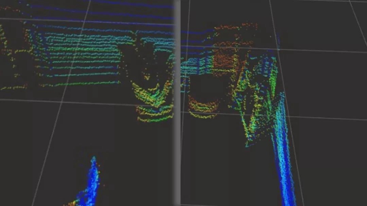
Point cloud images of various application scenarios of StarScan
The explosive growth of navigation lidar, the marginal expansion and reconstruction of the surveying and mapping lidar industry, and the emergence of handheld lidars. In the coming 2021, lidar has brought us too many surprises. All angles are inextricably linked with people's lives.
As the world's leading lidar manufacturer, Surestar always takes the needs of customers as its own development direction, insists on independent research and development, continuous innovation, to create more and better lidar products, to help the integration and reconstruction of the industrial margin, so that Lidar is recognized in more fields, allowing more people to feel the precise beauty of laser creation.(www.isurestar.net)