Skylark Lightweight Skylark Lightweight UAV LiDAR System
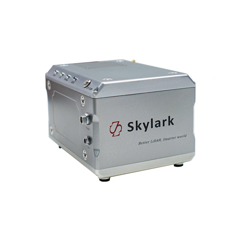
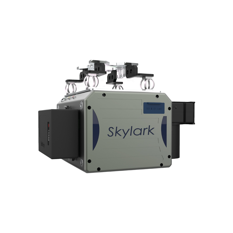


Skylark is SureStar’s best-in-class mapping LiDAR system specifically designed for larger drones and manned light aircraft. With an acquisition range of up to 1,500 meters, and a point density 3 times that of a small format 360° FOV airborne LiDAR, Skylark is the perfect choice for 1:500 topographic mapping and other high-density point cloud applications. Its uniquely high point acquisition rate means Skylark can be mounted to flying platforms ranging from large multi-rotor UAVs to fixed-wing aircraft with flying speeds of 100km/h. With cutting-edge technologies inside, Skylark has been applied to transmission line inspection, topographic mapping, 3D city modeling, water conservancy survey, forestry census, and geological disaster assessment.
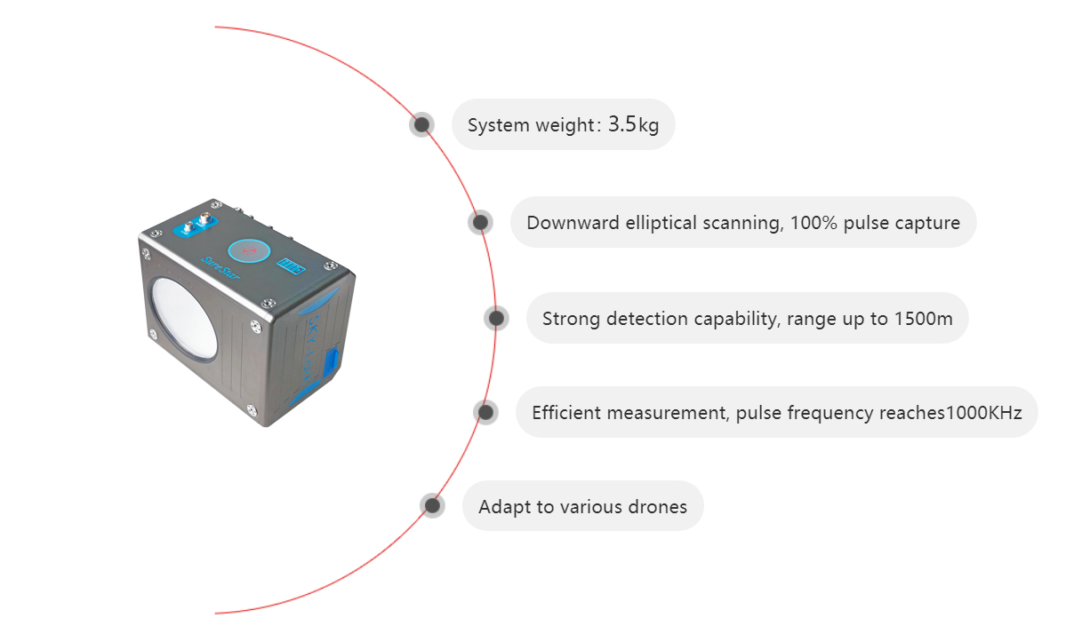
Max range: 1500 m
Elevation accuracy:< 5 cm
Plane accuracy:< 10 cm
Pulse frequency:1MHz
Scanning FOV:70°*40°
Laser safety: Class I
Laser echo: multiple
Flying altitude:100 - 700 m
Weight: 3.3 kg (no camera)
Operating temperature:-20~55℃
Scanning mode:Oblique ellipse
Scanning frequency:20~100 Hz
Mapping scale: 1:500 / 1000/2000 (no ground control point)


-
Lightweight Skylark Lightweight Skylark Lightweight UAV LiDAR System>
Skylark is SureStar’s best-in-class mapping LiDAR system specifically designed for larger drones and manned light aircraft. With an acquisition range of up to 1,500 meters, and a point density 3 times that of a small format 360° FOV airborne LiDAR, Skylark is the perfect choice for 1:500 topographic mapping and other high-density point cloud applications. Its uniquely high point acquisition rate means Skylark can be mounted to flying platforms ranging from large multi-rotor UAVs to fixed-wing aircraft with flying speeds of 100km/h. With cutting-edge technologies inside, Skylark has been applied to transmission line inspection, topographic mapping, 3D city modeling, water conservancy survey, forestry census, and geological disaster assessment. -
Skylark Lightweight Lightweight Skylark Lightweight UAV LiDAR System>
Skylark is SureStar’s best-in-class mapping LiDAR system specifically designed for larger drones and manned light aircraft. With an acquisition range of up to 1,500 meters, and a point density 3 times that of a small format 360° FOV airborne LiDAR, Skylark is the perfect choice for 1:500 topographic mapping and other high-density point cloud applications. Its uniquely high point acquisition rate means Skylark can be mounted to flying platforms ranging from large multi-rotor UAVs to fixed-wing aircraft with flying speeds of 100km/h. With cutting-edge technologies inside, Skylark has been applied to transmission line inspection, topographic mapping, 3D city modeling, water conservancy survey, forestry census, and geological disaster assessment. -
Lightweight Skylark Skylark Lightweight Skylark Lightweight UAV LiDAR System>
Skylark is SureStar’s best-in-class mapping LiDAR system specifically designed for larger drones and manned light aircraft. With an acquisition range of up to 1,500 meters, and a point density 3 times that of a small format 360° FOV airborne LiDAR, Skylark is the perfect choice for 1:500 topographic mapping and other high-density point cloud applications. Its uniquely high point acquisition rate means Skylark can be mounted to flying platforms ranging from large multi-rotor UAVs to fixed-wing aircraft with flying speeds of 100km/h. With cutting-edge technologies inside, Skylark has been applied to transmission line inspection, topographic mapping, 3D city modeling, water conservancy survey, forestry census, and geological disaster assessment. -
Lightweight Skylark Skylark Skylark Lightweight UAV LiDAR System>
Skylark is SureStar’s best-in-class mapping LiDAR system specifically designed for larger drones and manned light aircraft. With an acquisition range of up to 1,500 meters, and a point density 3 times that of a small format 360° FOV airborne LiDAR, Skylark is the perfect choice for 1:500 topographic mapping and other high-density point cloud applications. Its uniquely high point acquisition rate means Skylark can be mounted to flying platforms ranging from large multi-rotor UAVs to fixed-wing aircraft with flying speeds of 100km/h. With cutting-edge technologies inside, Skylark has been applied to transmission line inspection, topographic mapping, 3D city modeling, water conservancy survey, forestry census, and geological disaster assessment. -
Lightweight Skylark Lightweight Skylark UAV LiDAR System>
Skylark is SureStar’s best-in-class mapping LiDAR system specifically designed for larger drones and manned light aircraft. With an acquisition range of up to 1,500 meters, and a point density 3 times that of a small format 360° FOV airborne LiDAR, Skylark is the perfect choice for 1:500 topographic mapping and other high-density point cloud applications. Its uniquely high point acquisition rate means Skylark can be mounted to flying platforms ranging from large multi-rotor UAVs to fixed-wing aircraft with flying speeds of 100km/h. With cutting-edge technologies inside, Skylark has been applied to transmission line inspection, topographic mapping, 3D city modeling, water conservancy survey, forestry census, and geological disaster assessment.